DEPARTMENT OF INFRASTRUCTURE, TRANSPORT & REGIONAL DEVELOPMENT
Australians United Reform & Modernisation
(Modelled using your Industries & Science + Health & Disability structure)
🔵 1. Why Infrastructure Reform Matters
Australia’s infrastructure system — transport, freight, regional development, and national connectivity — underpins every part of the economy. But much of it was built for a different century.
Reform is needed because Australia faces:
-
Ageing transport networks
-
Congested freight corridors
-
Uneven regional development
-
Slow project delivery
-
Rising climate and resilience pressures
Infrastructure reform creates a unified national capability network that supports:
-
Clean manufacturing
-
Regional jobs
-
National supply chains
-
Emergency response
-
Economic growth
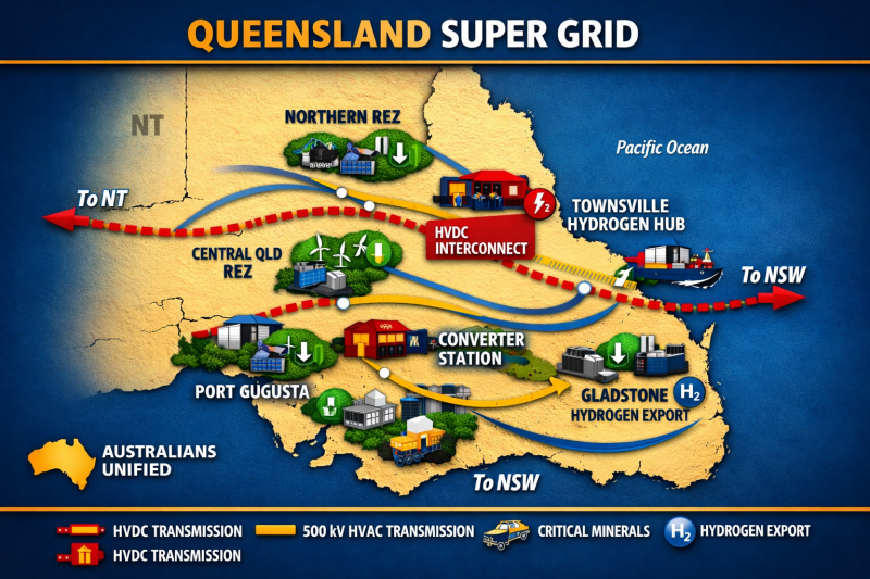
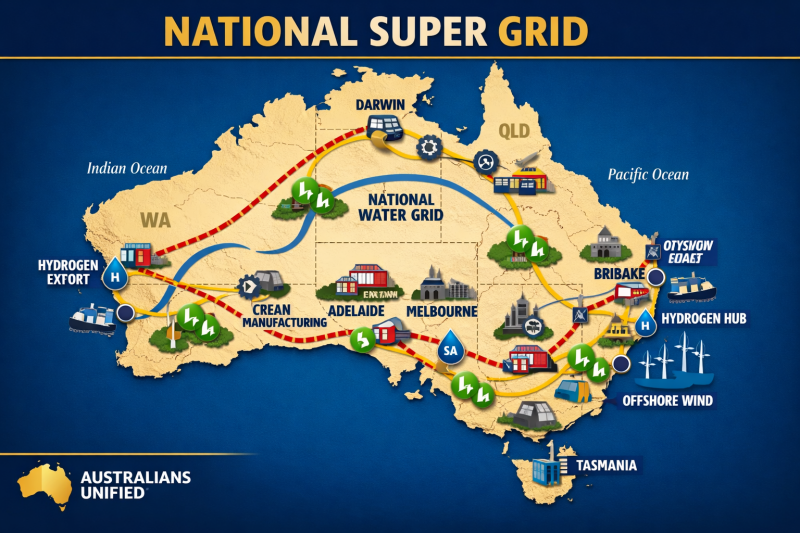
🟨 Queensland Super Grid
-
Focus: Renewable powerhouse & hydrogen export
-
Anchor: Gladstone Hydrogen Terminal
-
Summary: QLD drives national growth with solar, wind, and hydrogen export corridors.
-
Visual cue: Solar + wind icons + coastal hydrogen terminal
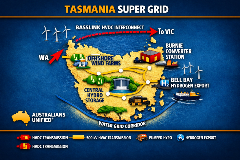
🟦 Tasmania Super Grid
-
Focus: Hydro & offshore wind
-
Anchor: Basslink HVDC
-
Summary: TAS delivers renewable stability through pumped hydro and offshore wind farms.
-
Visual cue: Dam + wind turbines + HVDC link northward
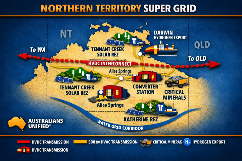
🟩 Northern Territory Super Grid
-
Focus: Solar backbone & minerals corridor
-
Anchor: Darwin Hydrogen Export
-
Summary: NT anchors the grid with solar REZs and critical minerals for clean energy.
-
Visual cue: Mining cart + solar field + port hydrogen icon
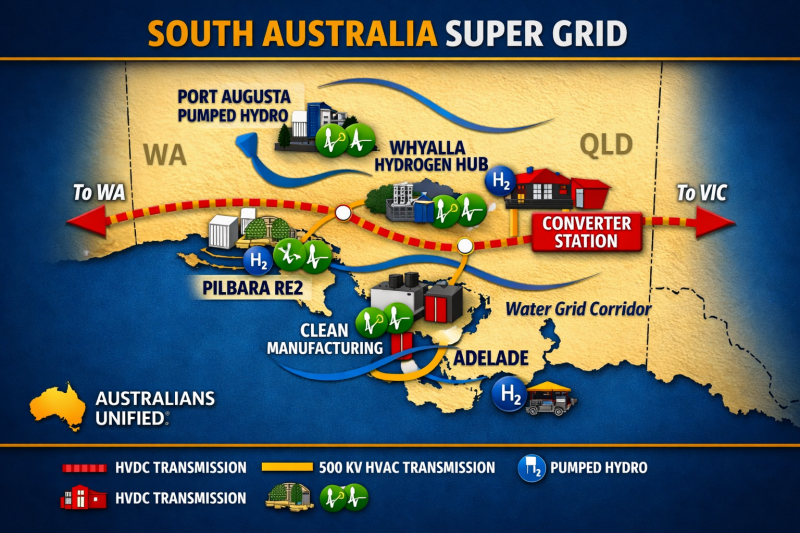
🟥 South Australia Super Grid
-
Focus: Clean manufacturing & interconnection
-
Anchor: Whyalla Hydrogen Hub
-
Summary: SA connects east and west through HVDC interlinks and clean industry zones.
-
Visual cue: Factory icon + dual HVDC arrows east–west

🟥 Victoria Super Grid
-
Focus: Transmission hub & manufacturing
-
Anchor: Latrobe Valley Converter
-
Summary: VIC integrates national HVDC links and clean manufacturing clusters.
-
Visual cue: Converter station + industrial zone + HVDC junction
National Infrastructure Capability Framework
(Mirrors the “capability corridors” model used in Industries & Science)
Australia’s future depends on four integrated infrastructure corridors:
1. National Transport Corridor
Modern, efficient, low‑emissions road, rail, aviation, and maritime systems.
2. Freight & Supply Chain Corridor
Fast, resilient, digitally‑tracked freight networks connecting regions to ports and markets.
3. Regional Development Corridor
Infrastructure that supports regional jobs, housing, services, and industry hubs.
4. Digital & Smart Infrastructure Corridor
Sensors, data, AI, and digital systems that make infrastructure safer, faster, and more efficient.
These corridors mirror the logic of the Super‑Grid — but applied to transport, freight, and regional capability.

🟨 New South Wales Super Grid
-
Focus: Energy coordination & export
-
Anchor: Hunter Hydrogen Hub
-
Summary: NSW coordinates east‑coast power flow and hydrogen export readiness.
-
Visual cue: Hydrogen hub + east‑coast HVDC corridor
What Infrastructure Reform Delivers
(Structured like “What the Reform Delivers” in your other portfolios)
Faster, Safer Transport
Reduced congestion, modern rail, upgraded highways, and safer roads.
Stronger Supply Chains
Efficient freight routes, modern ports, and resilient logistics.
Regional Prosperity
Infrastructure that supports housing, jobs, and local industry.
Climate‑Ready Infrastructure
Resilient assets built for extreme weather and long‑term sustainability.
Digital‑Enabled Networks
Smart infrastructure that reduces costs and improves performance.

🟦 Western Australia Super Grid
-
Focus: Hydrogen export & critical minerals
-
Anchor: Geraldton Hydrogen Port
-
Summary: WA powers the nation’s hydrogen future through Geraldton and Pilbara REZs.
-
Visual cue: Hydrogen port icon + red HVDC line westward
How Infrastructure Integrates With National Systems
(Mirrors the “integration” section used in Health & Industries)
Infrastructure reform integrates with national capability systems:
-
Energy Super‑Grid → powers transport, freight hubs, and regional precincts
-
National Water Grid → supports regional development and climate resilience
-
Critical Minerals & Manufacturing → relies on efficient freight and port access
-
Digital Infrastructure → enables smart transport, AI traffic systems, and logistics tracking
-
Emergency Management → requires resilient roads, airports, and communication networks
INFRASTRUCTURE, TRANSPORT & REGIONAL DEVELOPMENT
Reform Model (AMEND / REMOVE / CREATE)

🚦 TRANSPORT SYSTEMS
Road, rail, aviation, maritime | Safety & emissions | Modernisation programs
Purpose
Build a safe, modern, efficient national transport system that connects people, communities, and industry.
Reform Direction
-
Modernise ageing transport assets
-
Integrate transport with the Energy Super‑Grid
-
Reduce congestion and improve safety
-
Build climate‑ready transport networks
-
Strengthen national mobility and freight efficiency
Outcomes
-
Safer roads and rail
-
Faster travel times
-
More reliable public transport
-
Better access for regional communities
-
Lower transport costs for families

🚚 FREIGHT & SUPPLY CHAINS
Port upgrades | Freight corridors | Digital tracking & logistics
Purpose
Strengthen Australia’s supply chains to ensure goods move quickly, safely, and reliably.
Reform Direction
-
Build resilient freight corridors
-
Modernise ports and logistics hubs
-
Digitise freight tracking
-
Reduce bottlenecks and delays
-
Support national industry and exports
Outcomes
-
Lower cost of goods
-
More reliable supply of essentials
-
Stronger regional economies
-
Faster delivery times
-
Resilient supply chains during crises

🏡 REGIONAL DEVELOPMENT
Housing & infrastructure | Regional industry precincts | Local capability uplift
Purpose
Strengthen regional communities with the infrastructure, services, and jobs they need to thrive.
Reform Direction
-
Build regional housing and essential services
-
Develop regional industry and manufacturing hubs
-
Improve transport and digital connectivity
-
Support local businesses and workforce development
Outcomes
-
Affordable regional housing
-
Local jobs and industry growth
-
Better access to services
-
Stronger, more resilient communities
-
Reduced pressure on capital cities

SMART & DIGITAL INFRASTRUCTURE
Sensors & data systems | AI traffic management | National digital backbone
Purpose
Digitise Australia’s infrastructure to improve safety, efficiency, and national capability.
Reform Direction
-
Build a national digital backbone
-
Deploy smart sensors and data systems
-
Use AI to manage transport and infrastructure
-
Strengthen cyber resilience
-
Integrate digital systems across government
Outcomes
-
Safer roads and public spaces
-
Faster travel times
-
Reduced infrastructure costs
-
Better emergency response
-
More reliable digital services
🌧 CLIMATE & RESILIENCE
Disaster‑ready infrastructure | Long‑term climate standards | Resilient regional networks
Purpose
Ensure Australia’s infrastructure can withstand natural disasters and long‑term climate pressures.
Reform Direction
-
Build climate‑resilient roads, bridges, ports, and rail
-
Strengthen national disaster readiness
-
Modernise climate standards
-
Protect regional communities
-
Integrate resilience into all infrastructure planning
Outcomes
-
Safer communities
-
Reduced disaster recovery costs
-
More reliable infrastructure
-
Stronger regional protection
-
Faster recovery after extreme events
STRATEGIC MAP — THE FOUR INFRASTRUCTURE CORRIDORS
A unified national network connecting people, regions, industry, and supply chains

National Transport Corridor
Road • Rail • Aviation • Maritime
Strategic Route (Condensed)
-
Connects capital cities → major regional centres → remote communities
-
Aligns with high‑capacity highways, upgraded rail lines, modernised airports, and maritime routes
-
Integrates with Energy Super‑Grid nodes for zero‑emissions transport
Purpose
-
Faster, safer travel
-
Reliable public transport
-
Lower transport costs
-
Better access for regional Australians

Freight & Supply Chain Corridor
Ports • Freight Rail • Logistics Hubs • Export Routes
Strategic Route (Condensed)
-
Links resource regions → processing hubs → ports → Indo‑Pacific export gateways
-
Includes dedicated freight lanes, upgraded intermodal hubs, and digitally tracked logistics routes
-
Connects to critical minerals precincts, manufacturing hubs, and regional industry zones
Purpose
-
Lower cost of goods
-
Stronger supply of essentials
-
Faster delivery times
-
Resilient supply chains during crises

Regional Development Corridor
Housing • Services • Industry Precincts • Local Capability
Strategic Route (Condensed)
-
Runs through regional population centres, growth corridors, and emerging industry precincts
-
Connects housing, water, transport, digital, and community infrastructure
-
Anchored by clean manufacturing hubs, critical minerals processing zones, and agricultural logistics centres
Purpose
-
Affordable regional housing
-
Local jobs and industry
-
Stronger communities
-
Reduced pressure on capital cities

Smart & Climate‑Ready Infrastructure Corridor
Digital Backbone • Sensors • AI Systems • Resilient Networks
Strategic Route (Condensed)
-
Overlays the entire national network with digital infrastructure, AI traffic systems, and real‑time monitoring
-
Includes flood‑resistant roads, fire‑resilient corridors, and climate‑ready regional networks
-
Integrates with Emergency Management Australia for national disaster response
Purpose
-
Safer communities
-
Faster emergency response
-
More reliable infrastructure
-
Lower long‑term costs

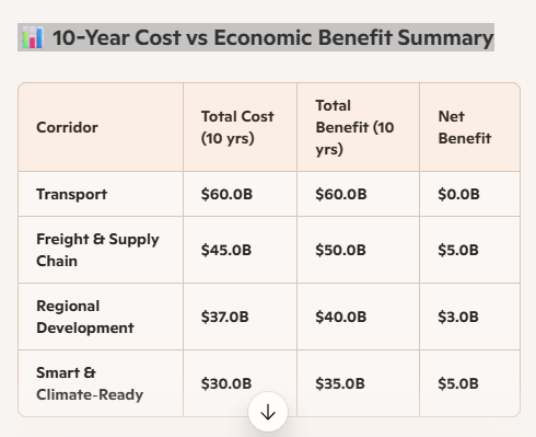
📊 10-Year Cost vs Economic Benefit Summary
The Freight and Smart Corridors deliver the strongest net gains, while Transport breaks even due to high upfront investment. A visual chart comparing cost vs benefit is included above.
Key Insights
-
Transport Corridor has the highest cost due to large-scale upgrades across road, rail, aviation, and maritime. It breaks even over 10 years, but delivers major social benefits like safer travel and regional access.
-
Freight Corridor delivers strong net gains by boosting port capacity, logistics speed, and export readiness — especially valuable for Indo-Pacific trade.
-
Regional Corridor supports housing, jobs, and decentralisation. Its modest net gain reflects long-term community uplift and reduced pressure on cities.
-
Smart Corridor offers the best return per dollar, with digital infrastructure and climate resilience driving lower long-term costs and faster emergency response.
Future‑Ready Interactive Visual Map Framework
Designed for the Infrastructure Portfolio — scalable across all Australians Unified portfolios
1. Layer‑Based Map Architecture (Core to Interactivity)
Your hybrid map is already structured around four corridors, which naturally become toggleable layers in an interactive version.
Interactive Layers
-
Transport Corridor Layer
-
Freight & Supply Chain Layer
-
Regional Development Layer
-
Smart & Climate‑Ready Layer
Why This Matters
-
Users can turn layers on/off
-
Each corridor can expand into sub‑maps
-
Supports future integration with Defence, Water, Energy, Home Affairs
This is the same architecture used by national GIS systems.
2. Corridor Nodes Become Clickable Points
Every node on your hybrid map can evolve into an interactive element:
Clickable Node Types
-
Capital cities
-
Regional hubs
-
Ports
-
Airports
-
Industry precincts
-
Super‑Grid intersections
-
Freight terminals
What Happens When Clicked
-
Pop‑up with project details
-
Regional investment summary
-
Local jobs impact
-
Infrastructure timelines
-
Climate‑resilience rating
This turns your map into a public transparency tool.
3. Strategic Boxes Become Expandable Panels
The four strategic boxes on the right side can evolve into:
Interactive Panels
-
Corridor overview
-
Key projects
-
Funding allocation
-
Regional benefits
-
Progress indicators
-
Before/after comparisons
This keeps the interface clean while allowing depth.
4. Real‑Time Data Integration (Future Phase)
Your map can later integrate:
Live Data Feeds
-
Traffic flow
-
Freight movement
-
Weather and climate alerts
-
Emergency routes
-
Infrastructure outages
-
Port and airport capacity
Why This Matters
-
Supports national resilience
-
Helps communities prepare for emergencies
-
Strengthens supply chain transparency
We offer a range of specialized services tailored to meet your individual needs. Our approach is focused on understanding and responding to what you require, providing effective and practical solutions.
