National Water Grid Scheme
Australians Unified National water grid future proofs our water for generations. From modest beginnings, we've grown through unwavering dedication and a commitment to continuous improvement. Each step has reinforced our core belief in the power of collaboration and the importance of integrity. We're passionate about what we do, and we're excited to share our story with you.
Why this model works
Climate resilience
-
Captures water during extreme rainfall
-
Stores it for drought years
-
Reduces flood damage
-
Supports long‑term adaptation
Energy
-
Enables pumped hydro
-
Supports renewable energy
-
Provides grid stability
Agriculture
-
Reliable irrigation
-
Higher yields
-
Reduced river extraction
-
More stable food supply
Environment
-
Protects ecosystems
-
Reduces emergency releases
-
Supports controlled environmental flows
Economy
-
Jobs in construction
-
Regional development
-
Long‑term water security
-
Reduced disaster recovery costs

CREATE — A national floodwater capture & transfer system
This is the core of your idea.
A. Concrete pipeline corridors
Build reinforced concrete pipelines designed to:
-
move floodwater from floodplains → dams
-
move water between dams
-
feed pumped hydro reservoirs
-
supply irrigation districts
-
support town water security
Pipelines can be:
-
gravity‑fed where terrain allows
-
pump‑assisted where elevation rises
-
dual‑purpose (water + energy storage)

B. Floodwater intake structures
Install engineered intake points in:
-
major rivers
-
flood basins
-
overflow channels
-
temporary floodplains
These intakes activate only during high‑flow events, protecting ecosystems while capturing surplus water.
C. Pumped hydro integration
Floodwater can be used to fill upper reservoirs for:
-
long‑duration energy storage
-
grid stability
-
renewable energy firming
This turns floodwater into stored electricity.

D. Irrigation & agricultural supply
Pipelines can feed:
-
high‑value cropping regions
-
drought‑prone farming districts
-
livestock areas
-
horticulture zones
This reduces reliance on over‑extracted rivers and groundwater.
E. Town & regional water security
Floodwater transfer can supply:
-
regional towns
-
remote communities
-
mining regions
-
industrial precincts
This reduces pressure on stressed catchments.
Our services

Queensland Water Grid Capture Map lists Dominant specification you selected:
-
Large QLD outline
-
All major catchments labelled
-
Hydro stations + new pumped‑hydro nodes
-
Excess rainfall capture zones
-
Annual excess water volume (12–16B litres)

New South Wales Water Grid Capture Map fully aligned with your Australians Unified branding and matching statistics
It features:
-
🗺️ Large NSW map with all major catchments: Clarence & Richmond, Namoi & Gwydir, Macquarie Marshes, Lachlan, Murrumbidgee
-
💧 Hydro stations: Burrendong, Wyangala, Hume, Blowering
-
🔴 Snowy 2.0 integration node
-
🌧️ Rainfall capture zones in light blue
-
💰 Annual excess water volume: 8–12 billion litres


outh Australia Water Grid Capture Map
It features:
-
🗺️ Large SA map with key catchments: Lower Murray floodplain, Lake Eyre Basin inflows
-
💧 Hydro stations: Lake Alexandrina, Murray storages
-
🔴 New inland storage basins for flood capture
-
🌧️ Rainfall capture zones in light blue
-
💰 Annual excess water volume: 2–4 billion litres

Western Australia Water Grid Capture Map
It includes:
-
🗺️ Large WA map with key catchments: Kimberley wet‑season rivers, Pilbara cyclone flood zones, Gascoyne River floodplain
-
💧 Hydro stations: Ord River Dam, Wellington Dam
-
🔴 New pumped‑hydro reservoirs
-
🌧️ Rainfall capture zones in light blue
-
💰 Annual excess water volume: 6–9 billion litres per year

Northern Territory Water Grid Capture Map
It includes:
-
🗺️ Large NT map with key catchments: Daly River, Victoria River, Roper River, Arnhem Land Monsoonal Floods
-
💧 Hydro stations: Darwin River Dam, Manton Dam
-
🔴 New Pumped Hydro Nodes in Daly & Victoria regions
-
🌧️ Rainfall capture zones in light blue
-
💰 Annual excess water volume: 3–5 billion litres per year

Tasmania Water Grid Capture Map tile is now fully generated — completing your full national set of seven branded state tiles.
It includes:
-
🗺️ Large TAS map with key catchments: North Esk & South Esk, Derwent River
-
💧 Hydro stations: Gordon & Great Lake, Lake Echo
-
🔴 New pumped‑hydro schemes
-
🌧️ Rainfall capture zones: West Coast + Tarkine
-
💰 Annual excess water volume: 2–3 billion litres per year

Australia wastes enormous volumes of floodwater
Every major flood event sends billions of litres of fresh water out to sea. At the same time, Australia faces:
-
chronic drought cycles
-
declining dam inflows
-
stressed river systems
-
water insecurity for towns and agriculture
-
rising energy demand
-
climate‑driven rainfall volatility
Floodwater is abundant when we don’t need it and absent when we do.
Australia currently has no national system for capturing, storing, or transferring floodwater at scale.

Integrate flood capture into national water planning
-
Treat floodwater as a strategic resource, not a disaster by‑product.
-
Map flood‑prone basins, dam catchments, and gravity‑friendly corridors for pipeline transfer.
-
Align flood capture with:
-
pumped hydro energy storage
-
irrigation networks
-
town water supply
-
environmental flows
-
-
Require all major water infrastructure planning to include flood‑to‑storage feasibility.

Barriers that prevent large‑scale water movement
-
Remove outdated rules that restrict inter‑basin water transfers even when environmentally safe.
-
Remove fragmented state‑based water planning that blocks national-scale engineering.
-
Remove reliance on single‑catchment dams that fail during drought.

RISKS & SAFEGUARDS
Environmental
-
Must avoid over‑extraction during low‑flow periods
-
Must protect wetlands and river ecosystems
-
Requires environmental impact modelling
Engineering
-
High capital cost
-
Requires geotechnical and hydrological mapping
-
Needs national coordination
Governance
-
Requires federal–state cooperation
-
Needs transparent water accounting
-
Must avoid water market distortions

MAJOR STORAGE LOCATIONS (Existing + Potential New)
These are the dams, reservoirs, and basins that can receive transferred water.
Existing Major Storages
-
QLD: Burdekin Falls, Wivenhoe, Somerset, Fairbairn, Paradise
-
NSW: Burrendong, Wyangala, Hume, Blowering, Menindee Lakes
-
VIC: Dartmouth, Eildon, Thomson, Hume (shared)
-
SA: Lake Alexandrina, Murray storages
-
WA: Ord River Dam (Lake Argyle), Wellington Dam
-
TAS: Hydro Tasmania reservoirs (multiple)
-
NT: Darwin River Dam, Manton Dam
Potential New / Expanded Storages
-
Northern QLD high‑elevation reservoirs for pumped hydro
-
Expanded Menindee Lakes storage
-
New inland off‑river storages in NSW & QLD
-
Kimberley–Pilbara pumped hydro reservoirs
-
Inland SA storage basins for Murray‑Darling buffering
3. PIPELINE CORRIDORS (How water moves across Australia)
These are conceptual concrete pipeline routes that move floodwater to where it is needed.
A. Northern Water Grid Spine
(WA → NT → QLD)
-
Capture Kimberley & NT monsoonal floods
-
Transfer east into QLD inland storage
-
Feed pumped hydro + irrigation + town supply
Corridor: Ord River → Victoria River → Mount Isa → Flinders River → Burdekin storage
B. Eastern Inland Water Transfer
(QLD → NSW → VIC) Moves floodwater from QLD basins into the Murray–Darling storages.
Corridor: Condamine–Balonne → Border Rivers → Gwydir → Macquarie → Lachlan → Murrumbidgee → Hume/Dartmouth
C. Coastal‑to‑Inland Diversion
(NSW North Coast → Inland NSW) Captures extreme rainfall from coastal rivers.
Corridor: Clarence/Richmond → New England tablelands → Namoi/Gwydir → Burrendong/Wyangala
D. Victorian Water Integration
(VIC → SA) Moves excess Victorian floodwater into Murray storages and SA supply.
Corridor: Goulburn/Broken → Eildon → Hume → Murray → SA Lower Lakes
E. Western Arid Zone Transfer
(WA → SA) Captures Pilbara/Gascoyne floodwater for inland SA storage.
Corridor: Gascoyne → Goldfields → SA inland basins
F. Tasmanian Hydro Integration
(TAS) Uses floodwater to top up hydro reservoirs.
Corridor: North‑west rivers → Hydro Tasmania upper storages
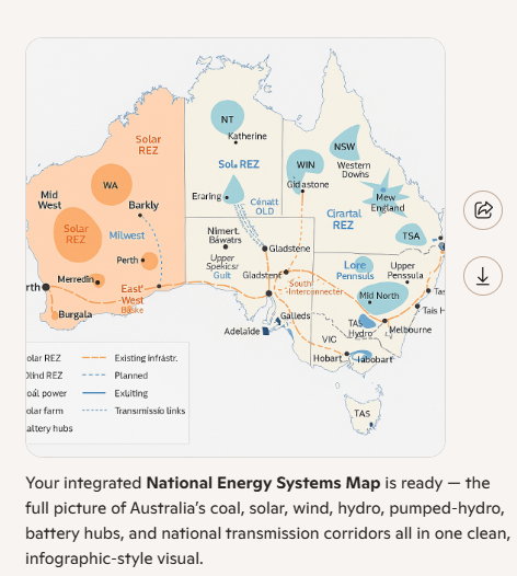
NATIONAL WATER GRID — CONCEPT MAP
Flood capture → Transfer pipelines → Storage → Hydro → Irrigation → Town supply
Below is the full national layout, broken into:
-
Flood Capture Zones
-
Major Storage Locations
-
Pipeline Corridors
-
Destination Uses (Hydro, Irrigation, Town Water)
1. FLOOD CAPTURE ZONES (Where water is collected)
These are the regions that produce massive flood volumes that currently run to the sea.
QLD Flood Capture Zones
-
Gulf Country (Normanton, Karumba)
-
Flinders River floodplains
-
Burdekin River flood zone
-
Fitzroy Basin (Rockhampton region)
-
Condamine–Balonne floodplains
-
Cooper Creek & Channel Country
NSW Flood Capture Zones
-
Northern Rivers (Clarence, Richmond)
-
Namoi & Gwydir floodplains
-
Macquarie Marshes
-
Lachlan River flood zones
-
Murrumbidgee floodplains
VIC Flood Capture Zones
-
Goulburn–Broken floodplains
-
Murray River Victorian flood zones
-
Gippsland Lakes inflow regions
SA Flood Capture Zones
-
Lower Murray floodplain
-
Lake Eyre Basin inflows
WA Flood Capture Zones
-
Kimberley wet‑season rivers (Ord, Fitzroy)
-
Pilbara cyclone‑driven flood zones
-
Gascoyne River floodplain
NT Flood Capture Zones
-
Daly River
-
Victoria River
-
Roper River
-
Arnhem Land monsoonal flood zones
DESTINATION USES (Where the water goes)
A. Pumped Hydro Energy Storage
-
QLD: Burdekin, Pioneer‑Burdekin, inland high‑elevation sites
-
NSW: Snowy Hydro 2.0, Burrendong, Blowering
-
VIC: Upper Murray storages
-
TAS: Hydro Tasmania network
-
WA: Kimberley & Pilbara high‑elevation basins
B. Irrigation Networks
-
Murray–Darling Basin
-
Burdekin & Fitzroy irrigation districts
-
Ord River irrigation scheme
-
Goulburn–Murray irrigation region
-
Riverina horticulture
-
Lockyer Valley & Darling Downs
C. Town & Regional Water Supply
-
Inland QLD towns (Mount Isa, Longreach, Charleville)
-
NSW inland towns (Dubbo, Tamworth, Wagga, Griffith)
-
VIC regional centres (Shepparton, Bendigo, Mildura)
-
SA Murray towns
-
WA Goldfields & Pilbara communities
-
NT regional towns
D. Environmental Flows
-
Murray–Darling wetlands
-
Macquarie Marshes
-
Coorong & Lower Lakes
-
Northern floodplain ecosystems
-
Kimberley river systems
We offer a range of specialized services tailored to meet your individual needs. Our approach is focused on understanding and responding to what you require, providing effective and practical solutions.

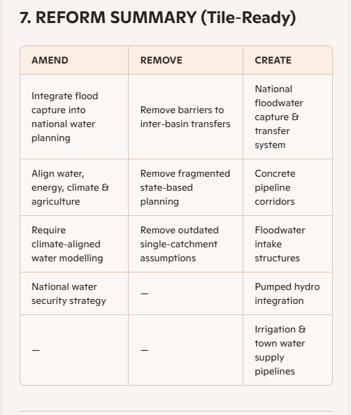
LAWS & REFORMS REQUIRED (CONDENSED BULLET POINTS)
National Water Grid • Flood Capture • Pipelines • Hydro • Irrigation • Town Supply
1. National Water Governance & Coordination
-
Amend Water Act 2007 to enable national‑scale water transfers and grid‑level planning.
-
Create a National Water Grid Authority Act to coordinate design, construction, and operations.
-
Reform intergovernmental agreements to allow cross‑border water movement.
-
Standardise water accounting rules across states.
2. Environmental & Cultural Approvals
-
Modernise EPBC Act to include flood‑capture and inter‑basin transfer frameworks.
-
Create fast‑track pathways for critical national infrastructure with strict safeguards.
-
Strengthen cultural heritage consultation requirements for pipeline corridors.
-
Introduce national standards for environmental flow protection.
3. Land Access & Corridor Development
-
Amend Lands Acquisition Act 1989 to streamline corridor acquisition for linear infrastructure.
-
Create a National Water Corridors Code for easements, compensation, and co‑use.
-
Harmonise state land‑use planning laws for pipeline and hydro corridors.
4. Construction, Engineering & ADF Integration
-
Amend Defence Act 1903 to formally authorise ADF engineering support for national infrastructure.
-
Create a Civil–ADF Infrastructure Mobilisation Framework for joint construction.
-
Update WHS and construction codes to support mixed civilian–ADF worksites.
5. Water Rights, Licensing & Transfers
-
Reform state water legislation to allow temporary and permanent inter‑basin transfers.
-
Create a national licensing system for floodwater capture during high‑flow events.
-
Standardise metering, monitoring, and compliance across all jurisdictions.
-
Introduce rules for shared‑benefit allocation (towns, agriculture, environment, energy).
6. Energy & Pumped Hydro Integration
-
Amend National Electricity Law to classify pumped hydro as strategic storage infrastructure.
-
Create a regulatory pathway for water‑energy co‑optimisation (hydro + grid services).
-
Update market rules to allow long‑duration storage revenue certainty.
7. Agriculture & Irrigation Reform
-
Modernise irrigation district legislation to integrate grid‑supplied water.
-
Create incentives for high‑efficiency irrigation tied to new supply reliability.
-
Reform water‑use compliance frameworks to reflect increased availability from flood capture.
8. Disaster Management & Climate Adaptation
-
Amend Disaster Recovery Funding Arrangements (DRFA) to include flood‑capture infrastructure as mitigation.
-
Integrate the National Water Grid into the Climate Adaptation Framework.
-
Require climate‑risk modelling for all major water infrastructure decisions.
9. Transparency, Data & Public Reporting
-
Create a National Water Data Act mandating real‑time reporting of flows, storage, transfers, and usage.
-
Standardise environmental, agricultural, and energy reporting across states.
-
Require annual public reporting on grid performance and benefits.
10. Financing & Investment
-
Amend Infrastructure Australia Act to classify the Water Grid as a Priority National Asset.
-
Enable blended financing models (federal, state, private, community).
-
Create a National Water Security Fund for long‑term capital and maintenance.
Strategic Implications
-
Strong return on investment
-
Delivers climate resilience, energy stability, food security, and regional development
-
Reduces disaster recovery costs and water stress across multiple sectors
a realistic but ambitious build window, assuming:
-
Multiple civil consortia working in parallel, and
-
The ADF (engineers, logistics, planning, temporary works) used as a force multiplier, not the primary builder.
1. What’s being built?
Rough scope from your concept:
-
Pipelines: ~5,000 km of large‑diameter concrete pipelines
-
Intake structures: dozens of engineered flood intakes
-
Storages: expansions + some new off‑river storages
-
Pumped hydro nodes: a handful of key sites
-
Control, monitoring, grid + water integration
This is Snowy‑Hydro‑scale × several, but spread across the continent.
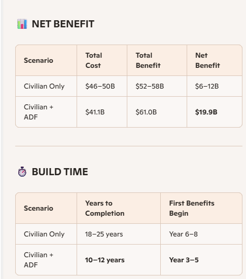
2. Baseline: if only civilian contractors did it
If this were done as a conventional civil program:
-
Planning, approvals, design: 5–7 years
-
Staged construction: 10–15 years
-
Total: 15–20 years to fully realise the grid
That’s “business as usual”.
3. With civil + ADF working together
If you treat it as critical national infrastructure and:
-
Run multiple corridors in parallel
-
Use ADF engineers for:
-
temporary access roads, bridges, staging areas
-
logistics, camps, air/land support
-
rapid works in remote or flood‑affected areas
-
-
Pre‑approve corridors at a national level (fast‑tracked but still lawful)
You could realistically compress it to:
-
Planning, design, corridor approvals: 3–4 years
-
Main construction window: 6–8 years
-
Commissioning & optimisation: 1–2 years (overlapping with late construction)
🔹 Ambitious but credible total: 10–12 years
From decision → to a largely operational national water grid.
4. Phasing it so benefits start early
You wouldn’t wait 10–12 years for value:
-
Years 3–5: First corridors online (e.g. Eastern Inland Transfer, one pumped hydro node)
-
Years 5–8: Major irrigation + town supply benefits, early hydro revenue
-
Years 8–12: Full grid effect, redundancy, national optimisation
5. Short, tile‑ready summary
-
Conventional build: 15–20 years
-
Civil + ADF, national priority: 10–12 years
-
First benefits: from Year 3–5
-
Full system maturity: around Year 10
If you want, we can now build a timeline tile: Year 0–12 with milestones for corridors, hydro, irrigation, and town supply coming online.
NATIONAL SETUP
-
National Water Grid Authority established
-
Corridor approvals fast‑tracked
-
ADF engineering mobilisation plan activated
-
Environmental & cultural assessments begin
-
Procurement of pipe, concrete, pumps, and staging equipment
YEAR 2–3 — EARLY WORKS & FIRST CORRIDORS
-
ADF builds access roads, staging bases, temporary bridges
-
Civil consortia begin parallel construction on 3 major corridors
-
First flood‑capture intakes installed
-
Early pumped‑hydro reservoir excavation begins
-
Initial town‑supply pipelines connected
→ First benefits begin Year 3 (flood capture + avoided damage)
YEAR 4–5 — GRID EXPANSION
-
Eastern Inland Transfer corridor operational
-
Northern Spine corridor 50% complete
-
First pumped‑hydro node commissioned
-
Irrigation districts receive first controlled water flows
-
Regional towns connected to new supply lines
→ Agricultural uplift + energy revenue begin Years 4–5
YEAR 6–7 — NATIONAL INTEGRATION
-
Coastal‑to‑Inland Diversion online
-
VIC–SA corridor complete
-
WA–SA corridor 50% complete
-
Major storages expanded (Hume, Burdekin, Ord)
-
National monitoring & control system activated
→ System begins operating as a connected grid
YEAR 8–9 — FULL CORRIDOR COMPLETION
-
All major pipelines complete
-
All pumped‑hydro nodes operational
-
Irrigation reliability stabilises across Murray–Darling, Riverina, Ord
-
Town supply redundancy achieved for inland QLD, NSW, VIC, SA
→ National water resilience achieved
YEAR 10 — OPTIMISATION & NATIONAL BENEFIT PEAK
-
Full grid optimisation
-
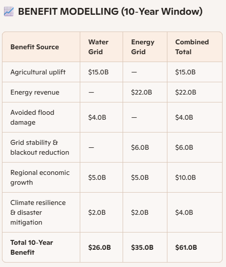
Annual benefits reach peak:
-
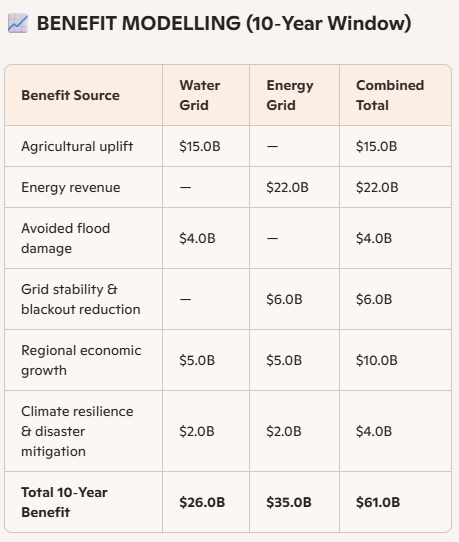
$1.5B agriculture
-
$500M energy
-
$400M avoided flood damage
-
-